

Swolszewice Duże Demo Site
Charakterystyka obszaru
The estuary stretch of the stream to the reservoir bay will be covered with measures aiming to reduce nutrient load coming from agricultural and forest catchment transported with the stream to the reservoir bay and contributing to toxic cyanobacteria bloom formation in this stretch.

| Owners | shares: 1/1 STATE TREASURY. Managing Authority: RBWM in Warsaw |
| Plot Number | 453/14 |
| Voivodship | łódzkie |
| Municipality | piotrkowski |
| Village | Wolbórz |
| Miejscowość | Swolszewice Duże |
| Cadastral Unit | 101011_2, Wolbórz |
| Section | No. 0030, Swolszewice Duże |
General Characteristics
General Characteristics
Swolszewice demo site is situated in the basin of a tributary from Golesze Duże, which directly supplies Sulejów Reservoir. Surface of the study stream basin covers 9.97km2. The basin’s river system is composed of the main stream (tributary from Golesze Duże) and its right-bank tributary outflowing at 0.3km. Length of the two streams covers 4.72km and 3.11km respectively. A system of drainage ditches, which contribute to the total river network density reaching 1.99km per 1km2, is an important element of the basin’s river network. The basin landscape is dominated by agricultural land and forests distributed along the river valleys.
Geological Structure
For the area of Swolszewice demo site, the Detailed Geological Map of Poland, Sulejów Sheet, scale 1 : 50 000, documents dominance of fluvial sands of alluvial terraces of the North Poland’s Glaciation, as well as Holocene fluvial sands. This characteristics of geological structure is supported by an archival geological cross-section running from South to North through Swolszewice demo site. It confirms presence of Pleistocene sands of alluvial terraces (North Poland’s Glaciation), which include of Holocene fluvial sands related with accumulative activity of the tributary from Golesze Duże. At the coordinate of about 157 – 163 metres above sea level, below these sand, the cross-dimension documents occurrence of drift clays formed during South Poland’s Glaciation, which are 10-15 metres thick, and under which there are deposits of chalky limestone, marls and sandy marls (Mesozoic).
In the course of installation of the piezometer network, detailed data concerning this area’s geological structure was gathered (Annex1: Map of the piezometer network location). Swolszewice demo is situated within fluvioglacial formations – terraces of upper valley terraces - piezometers S6 and S7, as well as formation of fluvial origin – in the tributary from Golesze Duże valley – piezometers S1, S2, S5, S8, S9 and S10 and in the Pilica valley on S3 beach. S4piezometre was installed within the connection zone of tributary from Golesze Duże, reservoir shoreline and incline terrace. The following sequence of formation occurrence characterises the spatial layout: from the slope of the upland to the reservoir shoreline: loamy sands and dusts covered with the youngest silts found along the valley course (perpendicularly to the reservoir banks and slope of the upland).
Hydrological Conditions
Within Swolszewice demo site, the first groundwater table has been found at the depth of 0.33 - 2.20 metres below the ground level (i.e. 166.11 – 166.24 metres above sea level). The water table is free in nature. Aquifer is formed of sands of various grain composition (fine, medium and coarse). The developed map of hydroizohips as well as the F-F’, G-G’, H-H’, I-I’, J-J’ hydrogeological cross-sections indicate that water flows from the north-east to the south-west direction. Sulejów Reservoir is the main drainage base level, although the layout of hydroizohips indicates that these characteristics also apply to the tributary from Golesze Duże.
Hydraulic connection between ground water with the waters of the tributary from Golesze Duże and Sulejów Reservoir has been confirmed in this demo site. The aquifer is mainly fed by atmospheric precipitation, and water level fluctuations depend on the volume of precipitation (both rain and snow). The material compiled has indicated that the water level fluctuations in the reservoir will affect the first groundwater table. Observations of piezometer S5, which is closest to the Sulejów Reservoir and the tributary from Golesze Duże, focused on mineral grounds have indicated insignificantly different groundwater level in relation to S4, which is a little more distant from the stream. This may be due to reservoir water damming (backwater).
Results of laboratory tests concerning the value of filtration co-efficient (within the range 27.61-39.36 according to Hazen method and 9.73-17.05 according to USBSC method) indicate that infiltrated aquifers zafiltrowane poziomy wodonośne are characterised by good filtration parameters.
Diagnoza zagrożeń
Chemical Characteristics of the Water in the Aquifer
Chemical analysis of the aquifer indicates the first class of purity of the first aquifer with respect to nutrient contents in accordance with the Regulation of the Minister of Environment of 23 July 2008 concerning the criteria and way of assessing the condition of groundwater. Phosphate concentration ranged between 0.001 – 0.255 mgPO4/l, with exception of the data for the sample collected on 30 September, when the concentration fluctuated between 0.13-1.15 mgPO4/l. Comparisons of water quality in the individual piezometers did not reveal any clear differences, and slightly higher values were recorded only in S1. Nitrate concentration in the aquifer ranged between 0.1 – 0.3 mg NO3/l.
Characteristics of Surface Water in Tributary from Golesze Duże
Current discharge measured with hydrometric current meter (VALEPORT meter, model 001 - series 8011 High Impact Styrene Impeller) ranged between 8.94 l/s – 19,5 l/s. Waters of the tributary constitute from 26.6% to 41.3% of the total value of the main current discharge.
Evaluation of surface water condition in the tributary from Golesze Duże with respect to the indicators for nutrient-related condition in accordance with the Regulation of the Minister of Environment of 20 August 2008 concerning the classification of the condition of uniform surface water bodies has classified the water as being below the good ecological status: concentration of phosphates ranged between 0.07 – 0.45 mg PO4/l, nitrates 0.6 – 12.4 mgNO3/l, and ammonia nitrogen 0.03 – 0.23 mg NH4/l . Total nitrogen concentration ranged between 0.8 – 7.1mg N/l and total phosphorus concentration between 0.18 – 0.78 mg P/l.
The average suspension contents in water reached similar values in the study stretch and was within the range of 11.1 mg/l – 12.1 mg/l. The highest recorded value of the total suspension reached 29.4 mg/l. These analyses indicate that organic suspension prevails in the water (average contents – 77.2%).
Characteristics of Hydromorphological Conditions in the Estuary Stretch
Due to its flood protection function, Sulejów Lake is characterised by a varied damming level depending on hydrological events in the Pilica basin, which results in water level fluctuations. The fluctuations observed strongly impact the estuary stretch of the tributary from Golesze Duże, within the level differences ranging from 166.60 to 165.90 in particular, which modifies the nature of this site’s functioning. At the value reaching 166.60 and more, the estuary stretch becomes a backwater, which results in intensive sedimentation processes taking places in the initial section of the estuary stretch. When this value is below 166.00, the stream flows quite vigorously to the very estuary of the Reservoir. These water level fluctuations have contributed to formation of sediment-built scarps which are free of vegetation.
Plant Communities
The following associations and communities have been identified in the stream valley: Salicetum albae, Glycerietum maximae, Magnocaricion, communities of hydrophytes and forest terophytes. Detailed distribution of the communities is demonstrated in the following map.
Salicetum albae is a forest complex, which is characteristic for low floodplains of medium and large-sized rivers, flooded annually or several times a year. It also grows in streams with seasonally emerging isles. Tree-stand is composed of S. fragilis and its crossbreeds. Herb layer of Salicetum albae is usually very rich, which has been recorded in the study site, and composed of numerous nitrophile species, such as: Galium aparine and Solanum dulcamara.
The swampy component (sub-association with Phragmites australis), which represents riparian forest in the stream estuary is mainly overgrown with Lysimachia vulgaris, Lythrum salicaria, Calamagrostis villosa and Solanum dulcamara (Matuszkiewicz 2007). All these species have been found in the study area.
Glycerietum maximae is a grass association which occupies relatively shallow (up to 0.8m), periodically drying-up, stagnant and flowing waters of various types of reservoirs and streams. It grows in the sites with clay, humus, muddy or peat substrata. Glyceria maxima is a dominant species, however this community is usually inhabited by a variety of other species. It is 1.5–2 m high (Podbielkowski and Tomaszewicz 1979).
Glycerietum maximae typically overgrows large patches adjacent to reed and aquatic plant communities, and Magnocaricion communities adjacent to land environment, which has been confirmed in the study area.
Magnocaricion community develops in low river valleys where depth of water seldom exceeds 0.5 m, and during the full vegetation season in many cases there is no surface water at all (Matuszkiewicz 2007). This has been confirmed in the study area.
Hydrophite communities: Free floating and rooted aquatic plants – hydrogeophytes (Podbielkowski Z., Tomaszewicz H. Zarys hydrobotaniki. Wydawnictwo Naukowe PWN, Warszawa, 1979) have been identified in this stream. Summer terophytes, Bidentetea, which are characterised by a very short vegetation season, have developed in the sites where organic matter cumulates.
Soil Characteristics
Analysis of the soil reaction results enables to classify the soil samples collected in the stream valley as acid in all the sites (the range: 4.52 at S6 and 6.17 at S10). Evaluation of contents of assimilable phosphorus (0.005 – 2.948 mg/kg of dry mass) and potassium (9.52 – 166.3 mg/kg of dry mass) in the soil has indicated low contents. Similar finding has been made for nitrogen (N-NO3: 2.1 – 294.14 mg/kg of dry mass; N-NH4: 5.7 – 180.2 mg/kg of dry mass), which indicates low productivity soil.
Analysing these results, a clear spatial distribution of nutrient contents in the soil is observed. The smallest amount of nutrients was found in the soil samples collected at the level of S8 piezometer and at S5, while significantly larger amount (even 64 times larger in case of N-NO3) in the central section of S6.
Bottom Sediments Characteristics
Based on a preliminary map of sediments in the estuary stretch (7 transects) of the tributary from Golesze Duże the sediments with thickness ranging between 25 and 100 cm were identified. The minimum thickness was recorded in the transect of direct estuary of the stream to the reservoir.
Analysing organic matter contents in the bottom sediment of the valley, the top accumulation of organic matter has been observed in the central section of the study stretch. Organic matter contents in the sediment sample collected in estuary stretch ranged from 2.32 to 14.56%, in the central stretch from 5.97% to 62.09%, and in the upper stretch from 1.41 to 6.89%.
Considering seasonal variations in the organic matter contents in the bottom sediment, it may be reported that its highest value was reached in autumn season (27.76% – 33.76%), and the lowest, in spring season (2.32% – 6.89%).
The following time-related variations in the bottom sediment reactions have been identified as result of the analyses: in November and April, neutral and slightly alkaline reaction (6.89 – 7.31), and acid (5.84 – 6.8) in July.
The total phosphorus concentration in the bottom sediments was low. The lowest values were recorded for the samples collected during winter season (7.4 µg P/ g of dry matter, February 2010), and after that, a gradual increase in the contents was observed in the course of vegetation season. The highest values were observed in the samples collected in late-autumn season (50.4 µg P/g of dry matter, November 2010).
The highest phosphorus concentration found in the study material was noted for NaOH-SRP fractions (phosphorus exchangeable with OH- ions, linked with metal oxides, Al and Fe in particular; inorganic forms of phosphorus soluble in alkaline environment) and NaOH-NO.P (phosphorus contained in micro-organisms, poly-P, organic forms of phosphorus contained in detritus, phosphorus linked with humus compounds). Average P concentration in these fractions reached 6.3 and 5.7 mg P/g respectively, i.e. approx. 30% share in TP.
Share of BD-SRP fractions (phosphorus sensitive to changes in redox potential, mainly bonded with FeOOH and Mn0 compounds), BD-NO.P (organic phosphorus) and HCl-SRP (phosphorus bonded with carbonates and apatites, trace quantities of hydrolysed organic phosphorus) reached approx. 10%, while the NH4Cl-P fraction (directly assimilable phosphorus contained in water close to sediment layer, loosely adsorbed on the surface of sediment particles and other elements or compounds, such as Fe and CaCO3 ), and HCl-NO.P (organic phosphorus forms) only 1%.
Results of analyses of sediment samples collected in the sites characterised by the highest accumulation of organic matter indicate the contents of certain metals below the threshold of limit of quantification (lead, cadmium, copper, chromium and nickel), zinc contents (average value reached 87.7 mg/kg) insignificantly exceeded the environmental value reported by Bojakowska and Gliwicz (2003) i.e. 73.00 mg/kg of dry mass. Only the result obtained for mercury (average value 0.1163 m/kg of dry mass) exceeds the environmental value (0.05 m/kg of dry mass) declared by the State Institute of Geology, however such sediments are still classified as non-polluted.
Microscopic analysis of the bottom sediment samples indicated presence of numerous cells of cyanobacteria, which under favourable physico-chemical conditions penetrate from sediments to water and generate cyanobacterial blooms, which are transmitted by water movement, and subsequently transported to the reservoir bay.
Proposed Project Solutions
Proposed Project Solutions
Toxic cyanobacterial blooms are one of key factors contributing to bad ecological capacity of Sulejów Reservoir. Multi-annual research into factors contributing to cyanobacterial blooms formation in Sulejów Reservoir, which has been delivered by the team chaired by Professor Maciej Zalewski, indicated that the bloom is generated in the bays and then it is spread by wind to the reservoir pelagial. The shallow bays which are additionally supplied with river water provide optimum conditions to cyanobacterial growth, thus recultivation of these sites is of key importance. The estuary stretch of the tributary from Golesze Duże is a site that particularly contributes to the bloom development.
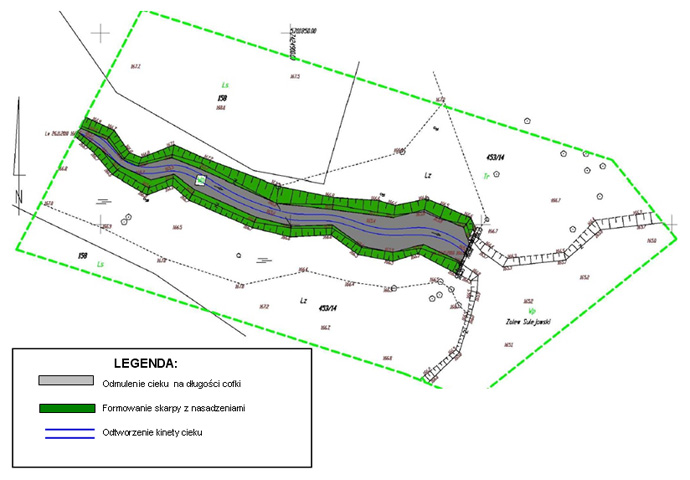
The estuary stretch of the stream is protected from wind and it facilitates fast increase in temperature of water and bottom sediments thus to development of spores of cyanobacteria deposited in the sediment and their transmission from the sediment to water. High contents of nutrients transported with inflowing water of the stream and with cyanobacteria released from the bottom sediments (internally supplied) facilitates fast propagation of the cyanobacteria and toxins they produce. In order to limit cyanobacterial bloom it has been proposed that the estuary stretch should be desludged (in the area of the backwater formation in the vicinity of 166.60 coordinate), which should help to remove cyanobacteria cells.
Current shape of the scarp reduces development of macrophites which use nutrients thus they are competition to cyanobacteria and by this are able to reduce their growth. Plantings in the backwater section in the estuary stretch will favourably increase sedimentation and reduce nutrient concentration in the inflowing water, stabilise sediment and reduce the release of internal load from the stretch leading into the reservoir. In order to increase the space for planting of macrophites, it is necessary to provide the scarp with appropriate shape. In order to ensure long-term improvement of water quality and having regard to the fact that bottom sediment collection in the estuary stretch is a natural phenomenon, it is necessary to implement measures aiming to reduce sediment deposition by reducing quantity of suspension reaching the estuary section by its sedimentation in the section above the estuary stretch. This will aid the process of desluging, which should be regularly performed every two years.
Installation of bionets with such phosphorus binding compounds as limestone, iron and bentonite, which are to reduce concentration of suspension and phosphates, have also been proposed for consideration. Bionets are structures suspended or floating in water with an aid of floats made of fibrous biodegradable material such as coconut fibre, cotton and jute, which when necessary may be strengthened with photodegradable polyethylene fibre or other reusable material resistant to degradation and providing increased resistance. Bionet’s capacity of removing the total suspension, nitrogen and total phosphorus ranges between 30-40%, and BZT5 20-30 % (Łągiewka 1994). Use of biodegradable fibres contributes to development of biofilm, which additionally improves efficiency of the net. Use of natural materials helps to resolve the issue of waste recycling that arises due to the use of filtration materials containing synthetic fibres. It is possible to biodegrade such materials and use them as high-grade organic fertiliser. However these measures cover also an area that is outside of plot No. 453/14, which is included in this project.
Water Equipment Planned
Construction of a pier above the estuary stretch from Golesze Duże to Sulejów Reservoir is proposed for Swolszewice Duże demo site. This pier will facilitate crossing through the stream in its estuary stretch. The pier’s deck will be located at the maximum reservoir damming level, i.e. 167.00 metres above sea level. It will consist of a frame made of timber pillars fixed in the stream-bed and scarps, a spar and deck composed of panels made of hard timber ( 15.0m x 2.0 m), and fencing.
Desludging of the stream along the backwater area, formation of the scarp with plantings, reconstruction of the stream’s inspection chamber base unit.


Earth Workss
Earth Works
Between September and November 2012, earth works were performed in the estuary stretch of tributary from Golesze Duże in Swolszewice Duże demo site, which included:
- Mowing coastal vegetation,
- Removing aggregate mud from the stream bottom,
- Shaping the stream scarp, which was strengthened with coconut mats and fascine,
- Planting of macrophytes and willow,
- Areas of intensified mineralisation in the form of the so-called alternate gravel and sand lenses were developed in the sites of matter sedimentation.


