Barkowice Łąka Demo Site
Charakterystyka obszaru
Optimisation of the existing and degraded ecotonic zones in the barren area vulnerable to strong pressure by tourists and diffuse pollution originating from agricultural and residential areas.

| Share owner | 1/1 STATE TREASURY. Managing Authority: RBWM in Warsaw |
| Plots Numbers | 1482/3; 1482/4; 1482/7 |
| Voivodship | łódzkie |
| District | piotrkowski |
| Municipality | Sulejów – Rural area |
| Village | Barkowice |
| Cadastral Unit | 101009_5, Sulejów – Rural area |
| Section | Nr 0002, Barkowice |
General Characteristics
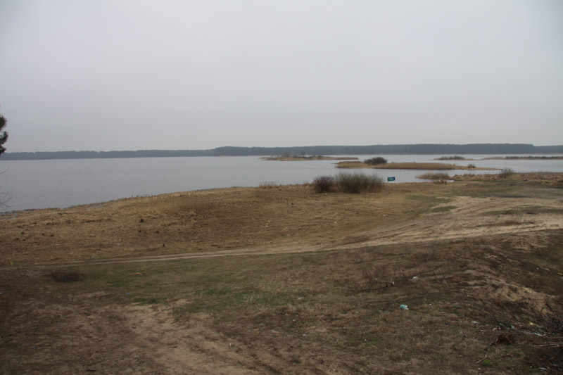
Barkowice demo site is located in an eroded fluvioglacial plain. At present, fluvial processes of the Pilica water (including seasonal fluctuations in the water level and fluctuations related with dam management) mainly impact land formation. Human activity aiming to increase the so-called tidal zone (beach) – digging the scarps and lifting land (reducing tidal zone – beach) in other locations, to increase land surface that potentially may be used for investments, is another key land formation element.
Geological Structure
For the area of Barkowice demo site, the Detailed Geological Map of Poland, Sulejów Sheet, scale 1 : 50 000, documents presence of lower fluvioglacial sands and gravels originating in the Central Poland’s Glaciation. In the course of installation of the piezometer network, detailed data concerning this area’s geological structure was gathered (Annex1: Map of the piezometer network location). Barkowice demo site is mainly composed of Pleistocene sands of various grain composition and lower fluvioglacial gravels originating from Mazowieckie Interglacial. Small patches are covered with the youngest sediments, i.e. silts, originating from the Pilica’s accumulative activity. They were confirmed only at B7.
Hydrological Conditions
In Barkowice demo site, the first groundwater table has been found at the depth of 0.35-1.60 metres below the ground level (i.e. 166.12 – 166.27 metres above sea level). The water table is free in nature. Aquifer is formed of sands of various grain composition (fine, medium and coarse). The study groundwater has full hydraulic connection with Sulejów Reservoir waters. The developed map of hydroizohips as well as the hydrogeological cross-sections (C-C’, D-D’ and E-E’) indicate that water flows from west to east. Sulejów Reservoir is the main drainage base level. The D-D’ hydrological cross-section developed indicates that locally, among the individual piezometers, minor corrections in the water discharge direction may take place, which however does not affect the main eastern direction of discharge. The aquifer is mainly fed by atmospheric precipitation, and water level fluctuations depend on the volume of precipitation (both rain and snow) and Sulejów Reservoir damming level. The material compiled has indicated that the water level fluctuations in the reservoir will affect the first groundwater table. Results of laboratory tests concerning the value of filtration co-efficient indicate that infiltrated aquifers are characterised by good filtration parameters.


Diagnoza zagrożeń
Chemical Characteristics of the Water in the First Aquifer
It has been reported that groundwater in Barkowice Łąka demo site is contaminated with nitrogen compounds. In the monitoring stations situated in the first line below the fault of the scarp (B6 and B12), and in the B10/B9/B8 transect, nitrate concentrations reached 100 mg NO3/l. It should be stressed that in the above mentioned monitoring stations, significant differences were noted between consecutive dates of sample collection (range of fluctuations reached 15 - 119mg/l), which may be explained by the impact of Sulejów Reservoir waters on quality of groundwater. Phosphate concentration observed in piezometers situated in the second line (closer to the shoreline; B7; B11; B13) reached significantly lower values. Maximum nitrate value in B13 reached 13 mg/l while in B7 and B11 2 mg/l and 1.7 mg/l respectively. Phosphate values in groundwater in Barkowice Łąka demo site ranged from 0.02 to 1.47 mg PO4/l. The highest concentrations were recorded at the stations in B10/B9/B8 transects. In B6/B13 and B12/B7 transects, phosphate concentration was falling toward the reservoir.
Characteristics of Surface Water in Sulejów Reservoir
Phosphate concentration in shoreline water ranged from 0.02 to 0.95 mg PO4/l, with the exception of 1 sample collected at the time of floodwave passage, when it reached 7.7 mg PO4/l. Nitrates concentration ranged between 1.68 and 9.83 mg NO3/l.
Plant Communities
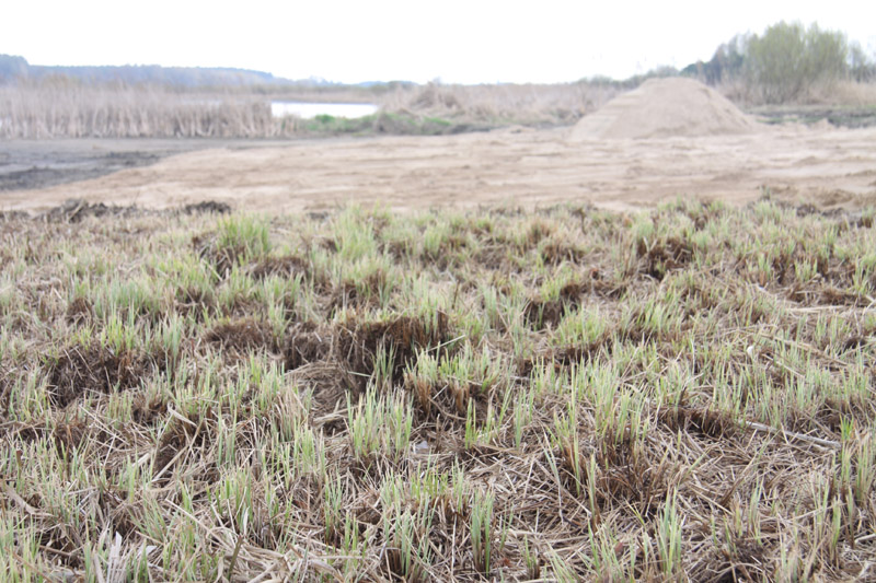
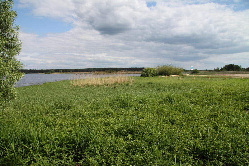
Barkowice Łąka demo site is characterised by co-occurrence of two zones. The first one is a “barren”: transport route on a devastated grassy community (due to treading and damage caused by cars; it also is littered). It is directly adjacent to naturally formed ecotonic zone, which has maintained mosaic and zoning layout and is overgrown with Glycerietum maximae, Phalaridetum arundinaceae, Phragmitetum australis, Magnocaricion and Typhetum latifoliae.
Characteristics of Soil and Bottom Sediments
Analysis of the soil reaction results enables to classify the soil samples collected in Barkowice Łąka demo site located in the vicinity of B7 – B10 piezometers as alkaline (7.37 – 7.69). Soil samples collected in the vicinity of B6 piezometer are acid (5.48), which is reflected in the existing plant communities. Soil samples contain small quantity of organic matter. The result values range from 0.79 to 2.84%.
Evaluation of assimilable phosphorus (0.02 mg/kg of dry mass) and potassium (19.99 mg/kg of dry mass) contents in the soil has indicated that the soil is very poor (5th class of productivity). Similar finding has been made for nitrogen (N-NO3: 5.29 mg/kg of dry mass; N-NH4: 12.77 mg/kg of dry mass), whose contents indicates low productivity soil.
Bottom sediments collected in the Reservoir’s shoreline zone in Barkowice Łąka are mineral. The highest contents of organic matter has been observed in late autumn (2.48%), while the smallest in July (0.96%). Samples collected in spring contained 1.11% of organic matter. This time-related distribution may be due to accumulation of dead plant tissues in autumn followed by its slow decomposition in spring, and total decomposition into mineral forms in summer. Reaction of bottom sediments collected from the reservoir is alkaline (7.46 – 7.69).
Proposed Project Solutions
Proposed Project Solutions
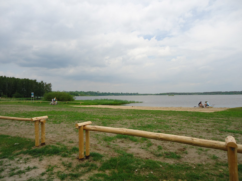
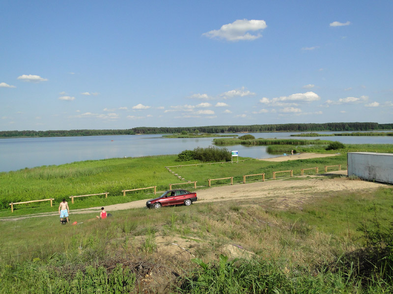
This region’s economic development and deteriorating quality of water in the lower section of Sulejów Reservoir (mass occurrence of toxic cyanobacterial blooms) increase pressure on picturesquely situated areas of the Reservoir’s backwater, such as the areas located near the village of Barkowice. Social consultations indicated that there is a strong need to create recreational sites. Unfortunately this is often achieved at nature’s expense. Barkowice Łąka demo site is intensively used for recreational purposes (illegal camp-site, weekend tourism), and soon these efforts will undergo further intensification due to investments (opening of a tavern and a windsurfing training centre). Lack of tourist infrastructure within the site contributes to its devastation.
Harmonising natural environment protection measures with needs of the local community constitutes a challenge, which may be demonstrated by the example of Barkowice Łąka demo site. On the one hand the measures should be oriented on maintenance of mosaic and natural ecotonic zones (e.g. 31/25/30/23 transects of vegetation patches) for the purpose of education. On the other hand, it is proposed that a site for recreational purposes should be identified, which following its appropriate management, will also protect the Reservoir from pollution entering its waters with surface runoff originating from precipitation and snow melt. For this purpose it has been proposed that a new meadow should be established in the wasteland. The meadow will constitute an extension of the ecotonic zone. 10 metre wide buffer zones overgrown with grass are able to intercept 40% more of phosphorus load from the surface runoff than the sites without such zones (Uusi-Kamppa, 2005). It is related with accelerated sedimentation of suspension in the grassy ecotonic zones, which is due to slower rate of surface runoff flow caused by such an ecosystem. Soil’s surface absorbs phosphorus compounds in the form of complexes, accelerated sedimentation of suspension contributes to reducing the phosphate load reaching the reservoir.
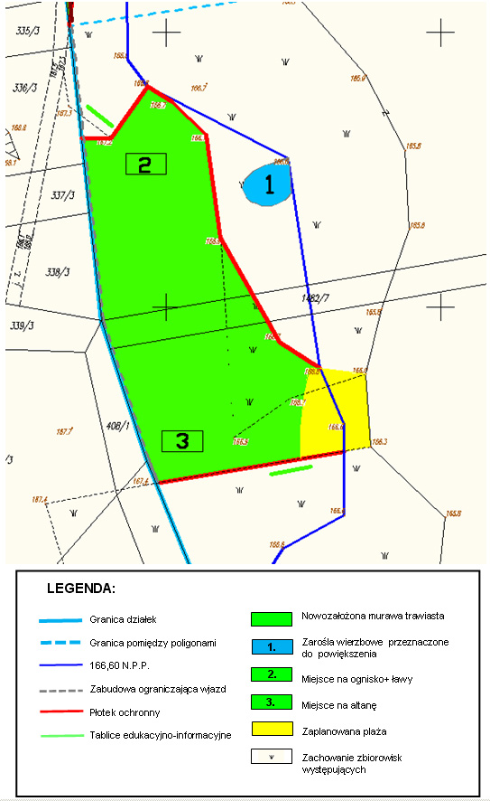
Borderline of the plots, Borderline between the demo sites166,60 N.P.P., Protective fence, Educational and information boards, Newly established grassy strand, willow shrubs planned for extension, site for a bonfire and benches, site for an arbour, beach planned, Maintenance of the existing communities
Earth Works
Earth Works
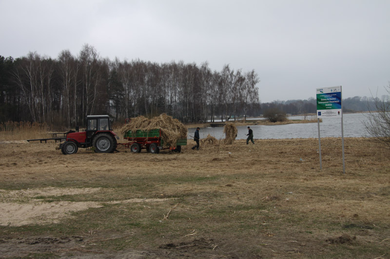
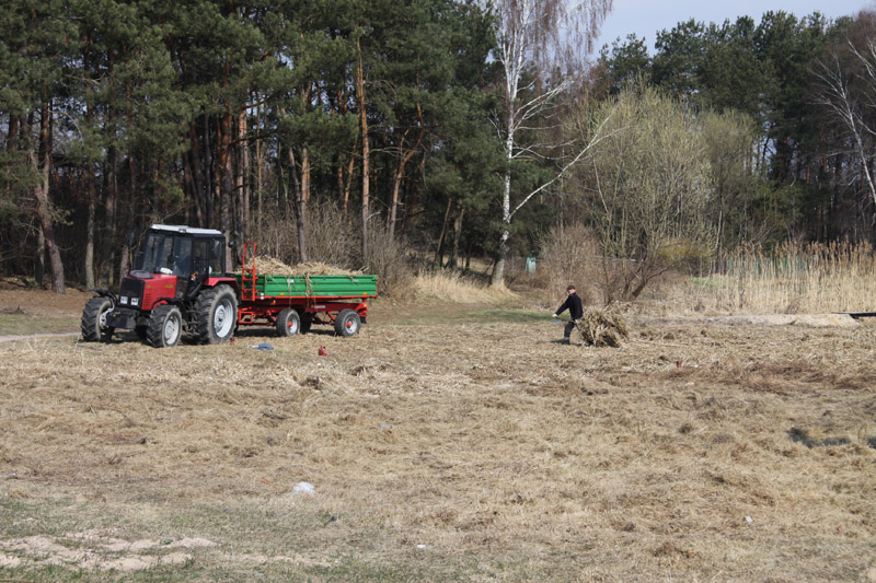
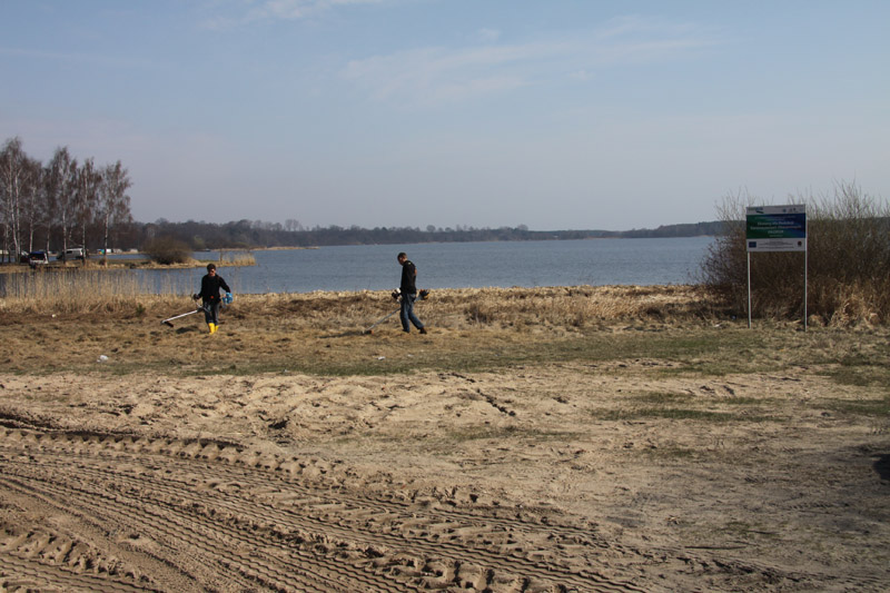
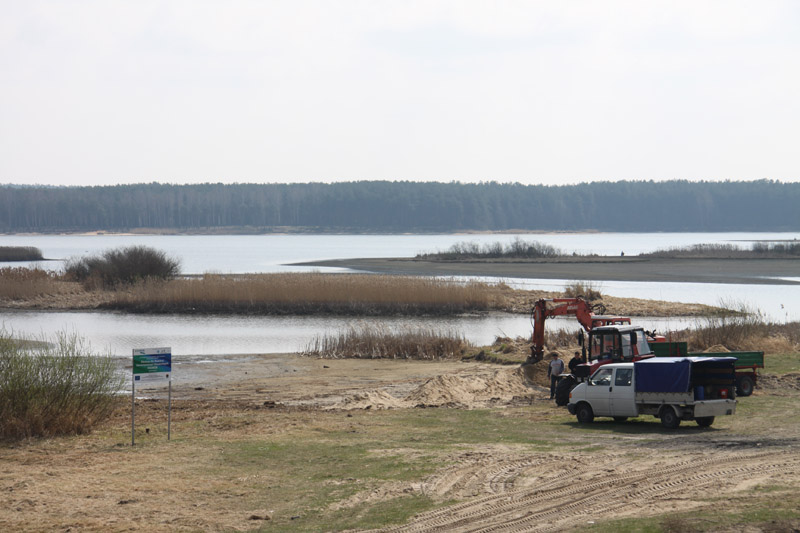
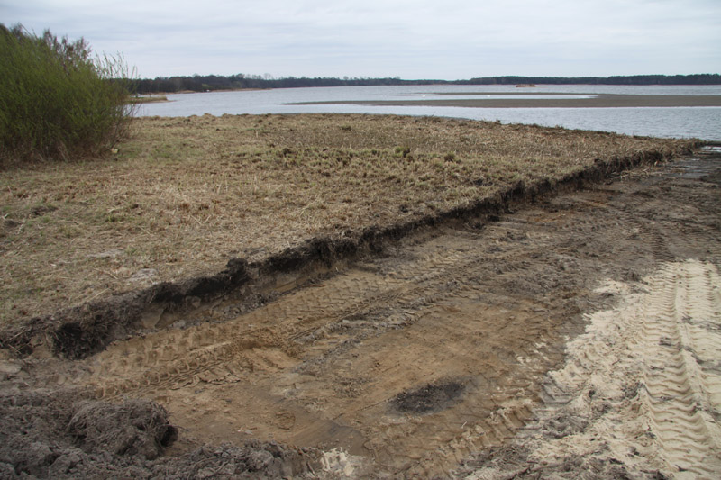
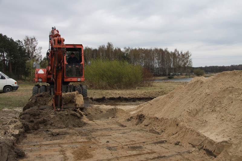
Between April and May 2012, works to construct ecotonic zones in the demo sites in the vicinity of Barkowice on the Sulejow Reservoirs to reduce diffuse pollution entering the reservoir and optimise the ecotonic zones vulnerable to strong pressures caused by tourists, were performed.
The following works were performed in the BARKOWICE ŁĄKA demo site:
- Mowing dead parts of plants in order to increase efficiency of the ecotonic zones by removing nutrient substances (nitrogen and phosphorus) from the plants’ tissues. The following data represent the type and quantity of ecotonic zone vegetation mown between the beach and cape (surface of approx. 0.5 ha), including the biomass mown: approx. 50 kg of nitrogen – equivalent to approx. 150 kg of ammonium nitrate (nitrate fertiliser) and approx. 5 kg of phosphorus – equivalent to approx. 25 kg Polifoska 6 (phosphatic fertiliser);
- Planting willows to increase willow shrubs, which due to their deep rooting system reaching up to several metres, significantly reduce the quantity of nutrient substances in underground water;
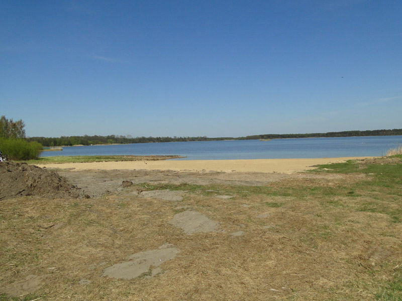
- A beach was formed using fine sand in the place of the former usual bathing site;
- Grass was sown in the part of the zone that had been damaged and overused by vehicles. For this purpose, soil was fertilised, necessary agro-technical procedures delivered and grass sown;
- Timber structures to limit access of vehicles to the demo site, and low fencing to prevent treading on the vegetation, were installed.
Additionally, during the holiday period, small tourist infrastructure elements were installed in the site, i.e. an arbor and benches near the place designated for bonfire.