Action Programme to Reduce Diffuse Pollution
In case of dammed reservoirs, such as Sulejow Reservoir, recultivation programme may not be limited only to the area of the reservoir. Due to continuous inflow of water from rivers, the programme of reducing the reservoir’s eutrophication should cover the whole basin of the Pilica and address both point and diffuse pollution sources. Thanks to investments delivered by local and regional authorities and industrial sector in order to increase number and efficiency of wastewater treatment plants, point pollution is gradually reduced. Unfortunately reduction of diffuse pollution is more complex and requires elaboration of relevant systemic solutions. Thanks to co-financing granted by the European Commission and the National Fund for Environmental Protection and Water Management to LIFE+ EKOROB Project, a programme of consistent and innovative solutions applying ecohydrological biotechnologies to limit sustainably diffuse pollution in the Pilica basin will be developed for this area. The programme will contribute to improving quality of water in Sulejów Reservoir. The foundation of the developed Programme will be provided by verification and integration of the available data on pollution coming to the Reservoir from the direct basin as well as inflowing with water of the Pilica and Luciąża rivers, based on the data received from the Regional Inspection for Environmental Protection (WIOŚ), Institute of Meteorology and Water Management (IMGiW), PIG, Regional Agro-Chemical Laboratories (OSCHR) and on project’s own data. Emissions of phosphorus and nitrogen compounds originating from point and diffuse sources in the Pilica basin will be quantified with an aid of MONERIS model (MOdelling Nutrient Emissions in RIver Systems; Leibniz-Institute of Freshwater Ecology and Inland Fisheries, Germany). The key feature of the model is the fact that it covers both major discharges of point pollution, which are easy to identify, and diffuse pollution sources, which are difficult to identify due to the complex nature of run-off formation processes. Analyses of both nutrients supply and their circulation are performed according to different “paths”- i.e. routes of supply: discharges from point sources (municipal WTP, industrial wastewater discharges, etc.) and loads introduced to surface water with atmospheric precipitation, groundwater, shallow drainage water, run-off from impervious surfaces from urbanised areas, erosion-originating products and surface run-off (Fig. 1).
Pollution migration processes are modelled in software environment combining statistical analyses using numerical data with analytical methods of the Geographic Information Systems (GIS) environment. Format of the modelling results enables to visualise them in GIS in the form of a map with editable set of attributes (maps of emissions, retention and nutrient loads, including their concentrations predicted in the environment and threshold nutrient concentration).
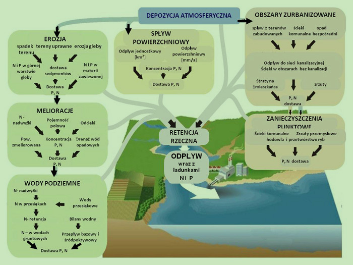
Fig. 1 Flow of nutrients supply in the basin according to MONERIS model guidelines.
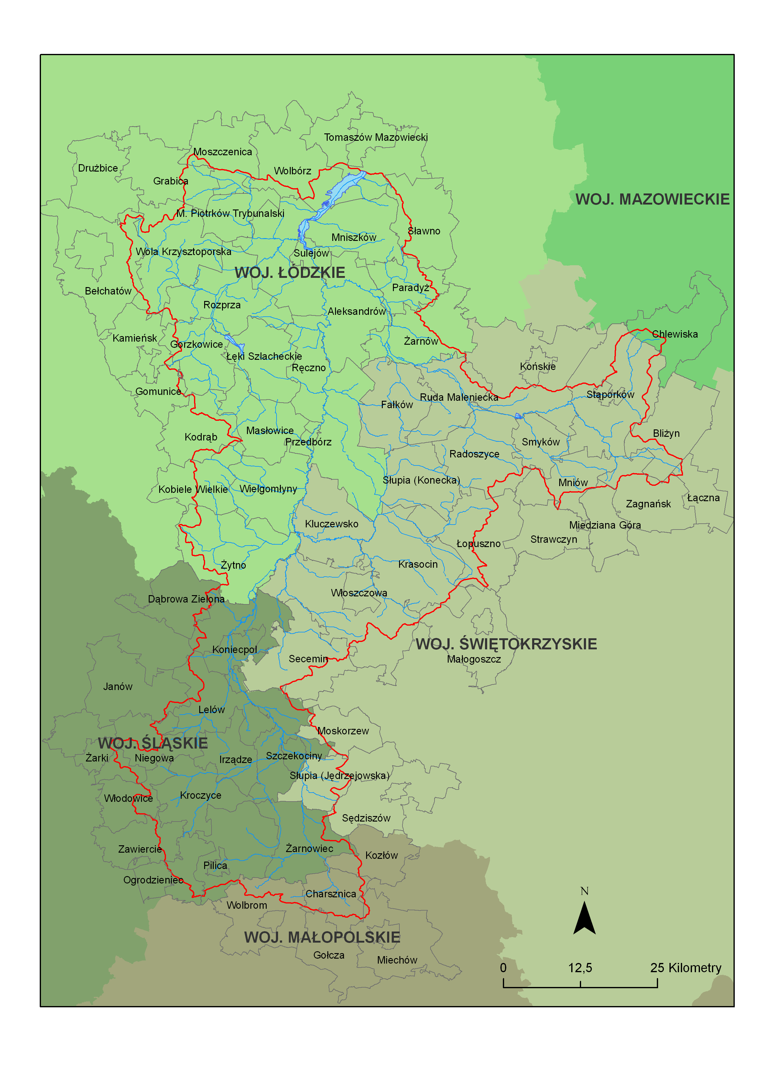
Action Programme will focus on reducing diffuse pollution in the Pilica basin located above Sulejów Reservoir, and it will cover 41 municipalities. It will aim at improving affected environmental quality standards and restoring required standards of surface and ground water quality in the context of the Water Framework Directive, Poland’s Environmental Policy and Regional Foresight. Apart from measures dealing with agricultural production activities, Action Programme elaborated under LIFE+ EKOROB Project will also cover the use of innovative ecohydrological biotechnologies as well as such additional measures as legal, administrative and economic instruments.
The following list represents elements that will be addressed in the process of developing this Action Programme:
-
Characteristics of natural conditions in the Pilica basin with special emphasis place on the stretch located above Sulejow Reservoir, including: description of geographic position, climate, geological structure and hydrogeological conditions, protected nature sites, etc.;
-
Social and economic characteristics of the Pilica basin, including such elements as.: demographics, economic profile, land use, etc.;
-
Water monitoring and evaluation of the basin water condition (in quantitative and qualitative terms) in the Pilica basin above Sulejow Reservoir and direct basin of Sulejow Reservoir
-
Identification of pressures and anthropogenic impacts in the form of: (1) point sources of pollution emissions, (2) dispersed sources of pollution emissions, including diffuse sources, (3) water intakes, (4) water engineering facilities;
-
Predicted directions of land development resulting from regional spatial development plans (regional development strategies), studies of conditions and directions of spatial development in municipalities, local spatial development plans with special emphasis placed on water management aspect;
-
Long-term land development scenario based on available planning documents or model (MONERIS) results;
-
Identification of key issues of water management in the upper section of the Pilica basin (above Sulejow Reservoir) based on results of the survey delivered by local authorities in 37 municipalities;
-
Environmental objectives adopted pursuant to Article 4 of WFD and derogations in the context of the environment objectives’ achievement – abstract from the Water Management Plan for the area of Wisła basin, including protected sites + lists (WFD – WMP) optionally;
-
Programme of actions envisaged for implementation in Sulejow Reservoir’s own basin;
-
Programme of actions envisaged for implementation in the upper section of the Pilica basin;
-
List of entities and competent authorities responsible for implementing actions, including an analysis of legal bases;
-
Cost analysis of the Action Programme, including identification of sources of financing;
-
Evaluation of impact of the Action Programme on the condition of water and natural environment in the Pilica basin and in Sulejow Reservoir;
-
Preparation of the Action Programme in the form of instructions for decision makers;
-
Promotion of the instructions among the bodies implementing the Action Programme and responsible for spatial planning;
-
Summary of the process of disseminating the Action Programme-related information among local communities.